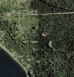
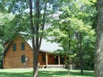
I don't know what it is but I'm fascinated with satellite photos. I can spend hours just looking at friends, family and city aerial photos. Here's a few of my place ...............
You are using an out of date browser. It may not display this or other websites correctly.
You should upgrade or use an alternative browser.
You should upgrade or use an alternative browser.
Having fun with MSN Vitual Earth
- Thread starter Big Dog
- Start date
B
bczoom
Guest
I believe they intentionally take them in the spring and fall (up here in the North).The satellites only take pictures inadvertently and can be any time of the year. My pictures appear to be from last fall. It's much greener here now.
In summer, too much foliage to see things. Ditto when there's snow.
I don't have any current information on it but there's software that's been developed that takes the images from 2 different points in time and identifies changes.
In particular (and what I heard it was intended for) is to allow local/county governments to get a list of changes (e.g. structures) so they can see if appropriate permits and taxations were performed.
BoneheadNW
Member
A related question: How does one take a snapshot in google earth to post it here?
Bone
Bone
In particular (and what I heard it was intended for) is to allow local/county governments to get a list of changes (e.g. structures) so they can see if appropriate permits and taxations were performed.
 Big Brother is really watching us all now.
A related question: How does one take a snapshot in google earth to post it here?
Bone
MW Snap free software for capturing images from your PC
http://www.snapfiles.com/get/mwsnap.html
BoneheadNW
Member
B
bczoom
Guest
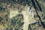
Islands can't have trees?Wow BH. Lots of trees around you. .....and I thought you lived on an island.


BoneheadNW
Member
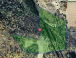
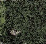
Here is a pic from a little further out. The images were taken while the house was being built, I would say around 2001, so there is no grass around the house. Our place is in the center of the pic and is bordered to the north by the road, to the west by the meadow, and to the south by the cul de sac.
Bone
Bone